Great Lakes Water Levels
Throughout my entire life I have always been outdoorsy. I like being in nature and I love swimming. I currently live near the shores of Lake Michigan and I have never seen the water higher than it is right now. The docks that we use to put our boat in the water are currently underwater. All of the shorelines that used to be beaches are gone and the water is eroding land. I recently took a trip to Michigan and everyone who has a house on the lake is rushing to put up break walls or are having boulders delivered to try to slow down the erosion of their backyards and flooding into their homes.
I specifically chose the water level of the Great Lakes as my topic because it is something that I am witnessing first hand almost every day. National Oceanic and Atmospheric Administration has a “Lake Level Viewer.” Anyone who accesses this application can use the data and map as a tool to illustrate potential flooding if the water levels rise or potential land exposure if the water levels decrease. Unfortunately, the data cannot account for erosion or future construction. In addition, water levels appear as they would during calm conditions, and as we know, the change in winds can have a tremendous impact on waves and flooding.

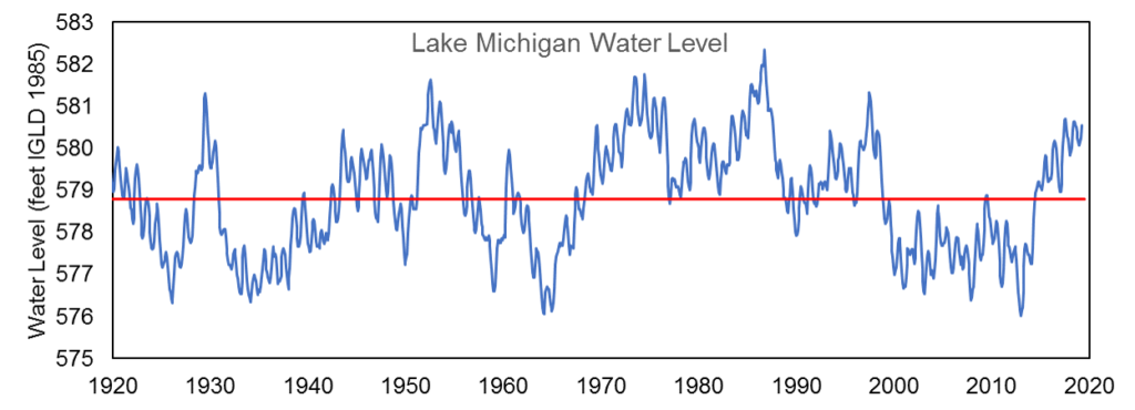
The Lake Level Viewer currently places our water level at 581.8 ft. The highest water level of Lake Michigan is marked at 582.4 ft and the lowest water level is marked at 576.0 ft. This means that we are only 0.6 ft (8 inches) away from an all time high. These water levels are only averaged from 1918. Before 1918, there were very few water level gauges in the Great Lakes, so the data would not be as accurate. All data concerning the water level, run off, precipitation, evaporations and outflows from the lake can all be found on US Army Corps of Engineers project: Lake Michigan Website.
So why are we seeing such an increase in water levels now? Mostly it is due to the amount of precipitation that we received last winter and into spring. On average Chicago receives about 3.68 inches of rainfall in May. But, this year we received 8.25 inches of rain which is a record rainfall amount. The soil can only soak up so much water and when the soil becomes supersaturated the water runs straight off into the Great Lakes.
There are many reasons that this information and data is essential for us. National Oceanic and Atmospheric Administration uses this data to predict costal management. “Costal management refers to actions that are taken to keep residents safe, the economy sound and natural resources functioning (NOAA).” This is only accomplished with the partnership of federal and state programs. “NOAA’s Office for Coastal Management oversees implementation and provides technical assistance .”
When Lake Michigan is calm it doesn’t pose as much of a threat. But, when the lake has a lot of waves it makes it not only more dangerous for those on the beach but can also cause serious shoreline erosion. Ethan Theuerkauf is a coastal geologist at the University of Illinois. Currently he is taking photos of the erosion at Illinois Beach State Park in Zion (literally 5 minutes from my home) for the Illinois Geological Survey. “We’re using this to basically generate a bunch of repeated, aerial photographs to quantify how the beach is eroding,” Theuerkauf said.

Theuerkauf’s photos show more than 100 feet of shoreline loss in some areas – and more than 300 feet in others. And the erosion does more than take away precious sunbathing space. Erosion leads to the loss of costal habitats which includes the homes to water fowl, costal animals and endangered plants. When the water level is high even the small waves can have a detrimental impact. “With the high lake level right now, a 2-foot or even 3-foot wave is going to generate some shoreline erosion. And of course when we get fall storms high lake level plus fall storms spell a lot of shoreline erosion,” he said.
The last time that the lake hit record highs was in 1986 and Chicago experienced a significant amount of damage to its lakefront. Over the last 30 years Chicago has spent more than 300 million dollars building shoreline protection , “which are designed to prevent flooding of Lake Shore Drive, protect the lakefront park system, and make sure that we’re ready for the next record high,” Joel Brammeier (President and CEO of the Alliance for the Great Lakes) said. He believes that Chicago should fare pretty well. The most damage will be seen in the smaller cities that do not have protection in place.
In conclusion, Lake Michigan’s water level is above average and only 8 inches away from reaching a record high. The rise in waters will continue through the fall. The high flood waters may not cause erosion. But if there are even small waves it can batter shorelines and eat away at the base of bluffs and dunes. In addition, erosion leads to the loss of coastal habitats which includes the homes to water fowl, coastal animals and endangered plants.
(n.d.). Retrieved July 21, 2019, from https://coast.noaa.gov/llv/#/lake/michigan
Great Lakes Dashboard Info Page. (n.d.). Retrieved July 21, 2019, from https://www.glerl.noaa.gov//data/dashboard/info/opLevels.html
Home. (n.d.). Retrieved July 21, 2019, from https://www.lre.usace.army.mil/Missions/Great-Lakes-Information/Great-Lakes-Information-2/Basin-Conditions/Basin-Conditions/#ICG_ETH_21547
Lake Michigan Nears Historic Water Levels. What’s Happening, and Why. (n.d.). Retrieved July 21, 2019, from https://news.wttw.com/2019/06/20/why-lake-michigan-nearing-historic-water-levels
Salus, L. (n.d.). SE WI COASTAL Resilience. Retrieved July 21, 2019, from https://sewicoastalresilience.org/lake-michigan-water-levels-remain-above-average-in-spring-of-2019/